By: Isabelle Job
Aerial Photography has been used in the Mediterranean region since the twentieth century as a tool for capturing the landscape. This capturing of the landscape has resulted in the creation of maps and borders. Even before modern map-making came into fruition with the innovation of aerial photography, the Mediterranean region has appeared in maps beginning in the Medieval era. One of these maps is found in a manuscript, the Silos Apocalypse (Burman, 184). The Silos Apocalypse is an example of a very early map created without accurate geographical representations (fig. 1). Yet, in the modern day, aerial photography has been used as an essential tool in creating accurate maps, but puts emphasis on borders. This essay will explore the development of mapmaking from the Medieval era and into the twentieth century with the development of aerial photography as a tool of warfare. Specifically, aerial photography was used as a tool of warfare by the British Royal Air Force in interwar Palestine in 1918. In addition, Fazal Sheik’s aerial photographs in his photographic series, The Conflict Shoreline, will be studied as a symbolic representation and artistic, political commentary on the conflict surrounding borders in the Israeli-Palestine region. Both case studies will explore the impact that aerial photography has had on mapmaking and the creation of ‘imaginary’ borders in the Mediterranean region. It will also touch upon the concepts of cousingage and fraternity that Naor Ben-Yehoyada defines within the politics of the region.
Maps of the Mediterranean date back to the Medieval Era, appearing in manuscripts and created by ancient cartographers. Among one of the earliest is the Solis Apocalypse World Map (Burman, 184). It is found in a manuscript completed between 1091 and 1109 at the monastery of Silos in Northern Spain (fig.1). The map represents the inhabited world based on what is considered to be classical notions of the globe, as summed up by the Spanish encyclopedist Isidore of Seville in his Etymologies (Burman, 184). This map is simplistic in its design, containing few colors and simple borders between land masses surrounding the ocean or Mediterranean Sea. The emphasis on the Mediterranean as the center of the world is significant and shows its importance for trade networks and the livelihoods of people living during this time. Aerial photography, in a similar way, seeks to photograph the world from above but creates geographically accurate borders.
Moving into the years post World War I, aerial photography was increasingly used as a tool for warfare. Caren Kaplan, in her book Aerial Aftermaths: Wartime from Above, says,
“Aerial imagery is popularly believed to provide the ultimate objective representation of what is on the “other side of the hill” — that is, what is beyond the immediate limit of human sight. Whether from a satellite, a drone, or a plane, the true value of photography…marks the view from above as beyond question” (Kaplan, 138).
The true purposes associated with aerial photography are emphasized in Kaplan’s book and are the reason why it is used as a tool for the military. Aerial photography allows sights to be seen that are not visible to the human eye, and from a new perspective. It is important to remember that Kaplan is discussing the use of aerial photography as a tool in general warfare. Still, her ideas can be applied to the use of aerial photography as a tool used for intelligence purposes in many parts of the world.
A case study of aerial photography is found in a series of images the British Royal Air Force took of the Palestine region in its interwar era in 1918. These images were taken in the midst of the Palestine Brigade by the British Royal Flying Corps. They were ordered to follow military initiatives in response to British General Allenby’s request for an air formation for his planned offensive against the Ottoman Empire in Palestine (Halstead, 166). The Australian Flying Corps also utilized aerial photography during this time and was commanded under the orders of the British Royal Flying Corps (Abusaada, 23). The historian James Halstead states that during this time,
“… there was a vast increase in photo negatives being produced, from 495 to over 1,149 between October and November 1917, while planning for Megiddo was aided by the assembly of sheet maps covering 4,500 km of territory from aerial photography” (Halstead, 166).
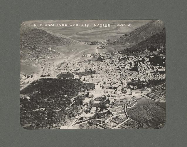
This increase in photography described by Halstead was led by Captain H. Hamshaw Thomas, who devised new cartographic methods that catered to the urban habitats of Palestine’s central region (Abusaada, 23). With the increase in these innovations, the photographs “served two purposes: mapmaking and intelligence” (Abusaada, 23). A photograph taken of Nablus, Palestine, in September 1918 is among many of the photographs taken by the Australian Flying Corps (fig.2). The photographer is known as Norman Henry Clutterbuck, whose albums contain mostly aerial photographs of locations in the Middle East (Museums Victoria Collections). This particular photograph depicts the city amidst the mountains, with clear borders between its urban environment and more desolate landscape. This photograph also appears to have been taken from a low altitude, allowing for accuracy in its depiction of the land. In another photograph shown on a photo album page, a barren landscape is shown (fig. 3). The barren landscape juxtaposes the urban environment seen in the other photograph but exemplifies the range of images taken of landscapes in order to create maps and configure borders. One of these maps is seen in Figure 4 and was created by Captain H. Hamshaw Thomas when viewing aerial photographs taken of the Palestine region (Abusaada, 23). Thus, these photographs and maps are exemplary examples of images taken from the sky being transferred into physical borders drawn on paper. They are ultimately showing the ‘other side of the hill,’ as Kaplan says, in their pursuit of military campaigns.
Not only has aerial photography been used by the military as a tool for warfare, but photographers such as Fazal Sheik have captured landscapes with the purpose of making political statements and commenting on issues regarding borders in the Mediterranean region. In his series, The Conflict Shoreline, Sheik collaborated with the architect Eyal Weizman. In these photographs, Sheikh captures aerial photographs of the Negev Desert and comments on the Israeli-Palestine conflict (fig. 4). His art is created in response to colonization, cultivation, displacement, urbanization, and climate change. While these photographs were taken for artistic purposes and not for warfare and border-making, Sheikh’s work encapsulates the purpose behind aerial photography: to photograph the land. In a review of the series created by Weizman and Sheik, Kareem Rabie states, “the shifting boundary divides landscapes…and in doing so it marks legal boundaries, styles of life, rights, and property” (Rabie, 195). Rather, boundaries created through political disputes and captured through photography, such as in the series The Conflict Shoreline, serve to represent the creation of borders in disputed lands, while they may just be imaginary.
Aerial photography, as used by the British Royal Air Force and in the artistic series The Conflict Shoreline, comments on the theme of border control and mapmaking. With the creation of borders with the use of aerial photography and mapmaking has come a separation of people and nations in the Mediterranean region. In this regard, Naor Ben-Yehoyada discusses the ideas of fraternity and cousingage when discussing this separation of nations. He says, “fraternity is the only kinship term that has survived the rise of academic interest in transnationalism, making “imagined communities” the imaginary building blocks of a world turned global” (Ben-Yehoyada, 873). The term ‘imagined communities’ that he refers to can be discussed in the context of aerial photography. Truthfully, the borders that are defined and created with the use of aerial photography could be considered imaginary, as there are no physical geographical lines creating these boundaries. Rather, the use of aerial photography has heightened political tensions in the Mediterranean, specifically in the Israeli-Palestine region. As seen in the works by Sheik, tensions continue into the modern-day in regard to the ever-present disruption of border-making in the Mediterranean region, which began with the use of aerial photography to create maps.
Figures

Figure 1: Silos Apocalypse world map, 1091-1109, Manuscript, parchment on vellum, Beautus of Liébana, British Library, London, Add Ms. 11695.

Figure 2: Nablus, Palestine, Middle East, 24 September 1918, Museums Victoria Collections.

Figure 3: Nablus, Palestine, Middle East, 24 September 1918, Two Images from photo album, Museums Victoria Collections.

Figure 4: Example of reconnaissance map worked up from a strip of overlapping photographs from Captain H. Hamshaw Thomas, “Geographical Reconnaissance by Aeroplane Photography, with Special Reference to the Work Done on the Palestine Front,” Geographical Journal 55, no. 5 (May 1920): 349-70, taken from Nadi Abusaada, Combined Action: Aerial Imagery and the Urban Landscape in Interwar Palestine, 1918-40.

Figure 5: Image from The Conflict Shoreline, Eyal Weizman and Fazal Sheikh, 2021.
Bibliography
Abusaada, Nadi. “Combined Action: Aerial Imagery and the Urban Landscape in Interwar Palestine, 1918-40.” Palestine From Above. Jerusalem Quarterly, no. 81 (2020): 20-36. https://www.palestine-studies.org/en/node/1650011.
Burman, Thomas E and Brian A. Catlos, and Mark D. Meyerson. The Sea in the Middle : The Mediterranean World, 650–1650. Oakland, California: University of California Press. 2021. https://search.ebscohost.com/login.aspx?direct=true&db=nlebk&AN=3306685&site=ehost-live.
Gordon, Neve. Israel’s Occupation. Berkeley: University of California Press, 2008.
Halstead, James. “Air Power and Allenby’s Army: Combined Arms in Palestine 1917–1918.” War in History 29.
“Interview with Eyal Weizman.” International Review of the Red Cross (2005) 98, no. 901 (2016). 21–35.
Kaplan, Caren. Aerial Aftermaths: Wartime from Above. 1st ed. Melton: Duke University Press, 2018.
Museums Victoria Collections. “Photograph, Nablus, Palestine, Middle East, 24 Sep 1918.” https://collections.museumsvictoria.com.au/items/1751381.
Rabie, Kareem. The Arab Studies Journal 24, no. 2 (2016): 195–99. http://www.jstor.org/stable/44742889.
Shams, Ahmed. 2016. “Mapping and Mapmaking in the High Mountains of Sinai Peninsula: A Review and the Revival of the 19th Century CE Practices.” Palestine Exploration Quarterly 148 (3): 188–210. doi:10.1080/00310328.2016.1201738.
Weizman, Eyal, and Fazal Sheikh. The Conflict Shoreline: Colonization as Climate Change in the Negev Desert. Edited by Liz Jobey, Shela Sheikh, and Michael Komem. First edition. Göttingen, Germany: Steidl, in association with Cabinet Books, Brooklyn, 2015.
Yehoyada, Naor Ben. “Transnational Political Cosmology: A Central Mediterranean Example.” Comparative studies in society and history 56, no. 4 (2014): 870–901.
